Task Management System
Land Records Management System Development for African Governments (2026 Guide)
- Written by
Shishu Yadav - Posted on
Jun 29, 2026
Land disputes are among the most persistent sources of conflict, economic inefficiency, and lost investment across Africa — and at the root of most disputes sits the same problem: incomplete, inconsistent, or easily manipulated paper-based land records. From customary land tenure systems in Ghana and Nigeria to formal title registries in Kenya and South Africa, and the particularly complex land administration challenges facing Libya and Somalia, land records management system development has become one of the most consequential digital government investments a country can make.
This guide covers what a modern land records system includes, how it reduces disputes and unlocks economic value, realistic development costs, and how African governments should approach this kind of high-stakes digitization project.
Unlocking Collateral Value — Without reliable, verifiable land records, landowners across much of Africa cannot use their land as collateral for credit, locking enormous amounts of economic value out of the formal financial system.
Reducing Land Disputes — Conflicting or duplicate land claims caused by poor record-keeping fuel a significant share of civil litigation and, in some regions, violent conflict. Accurate digital records with clear chain-of-title history directly reduce dispute frequency.
Attracting Investment — Foreign and domestic investors consistently cite unclear land tenure as a major barrier to investment in agriculture, real estate, and infrastructure projects across the continent.
Supporting Customary and Formal Tenure Systems — Many African countries operate dual land tenure systems — customary/communal land alongside formally titled land — and a well-designed system needs to accommodate both rather than forcing a one-size-fits-all formal title model that doesn’t reflect on-the-ground reality.
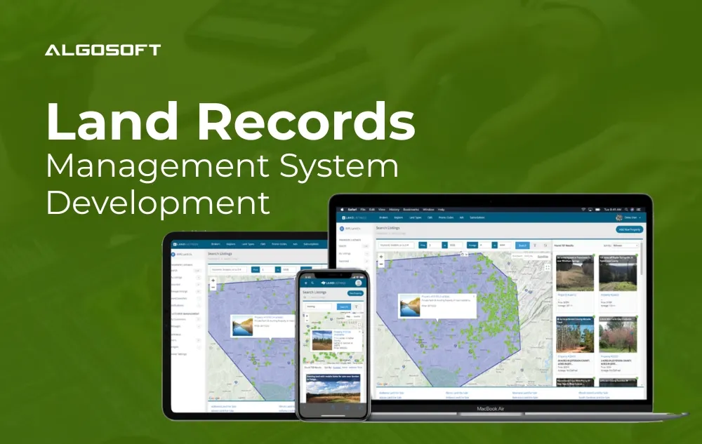
1- Digital Land Registry Database A centralized, authoritative digital record of land parcels, ownership history, encumbrances, and boundary information, replacing fragmented paper files often scattered across multiple regional offices.
2- GIS Mapping and Parcel Boundary Visualization Geographic Information System integration that maps land parcels visually, resolving boundary ambiguities that paper-based records frequently leave unclear.
3- Chain of Title and Transaction History A complete, tamper-evident history of every transaction affecting a given parcel — sales, inheritance, subdivisions, encumbrances — creating a verifiable record that resolves competing ownership claims.
4- Customary Land Recognition Workflows Configurable workflows that formally record customary and communal land rights alongside formal title, recognizing tenure systems that remain dominant across large parts of rural Africa.
5- Land Transaction Processing Digital workflows for processing sales, transfers, subdivisions, and inheritance transactions, with integrated fee collection and automatic registry updates.
6- Dispute Flagging and Resolution Tracking A structured mechanism for flagging disputed parcels and tracking resolution status, providing courts and land tribunals with a clear digital case record.
7- Public Verification Portal A citizen-facing portal allowing prospective buyers, lenders, and other stakeholders to verify land ownership and encumbrance status before completing transactions — a powerful tool against land fraud.
Blockchain for Tamper-Proof Records Some African land registry modernization projects are exploring blockchain-based recordkeeping specifically because it creates an immutable, cryptographically verifiable transaction history — directly addressing the record manipulation risk that plagues paper-based systems.
GIS and Satellite Imagery Integration Combining land registry data with satellite imagery and GIS mapping helps resolve historical boundary ambiguities and supports more accurate parcel surveying, particularly important in rural areas where formal surveying has historically been limited.
Data Migration from Paper Archives One of the most resource-intensive parts of any land records digitization project is migrating decades of paper records into structured digital format — a process that requires careful planning around data quality, conflicting historical records, and verification workflows.
Offline Capability for Rural Land Offices Given that land transactions frequently occur in rural areas with limited connectivity, offline-capable functionality with periodic synchronization is essential for practical, nationwide adoption.
| Project Scope | Estimated Cost Range (USD) | Typical Timeline |
| Pilot District/Region Digitization | $70,000 – $180,000 | 5–8 months |
| Multi-Region Platform with GIS Integration | $250,000 – $600,000 | 12–18 months |
| Full National Land Registry Modernization | $600,000 – $2M+ | 18–36 months |
Costs vary substantially based on the volume of historical records requiring migration, the level of GIS and satellite imagery integration, and whether the project needs to formally accommodate customary land tenure recognition.
Nigeria — With land governed by a mix of statutory and customary law across Nigeria’s diverse states, land records systems typically need significant configuration flexibility to accommodate varying state-level land administration practices.
Kenya — Kenya’s National Land Commission has been actively pursuing digitization, making integration with existing digital land initiatives an important consideration for any new system component.
Ghana — With customary land ownership covering a significant majority of Ghana’s land area, Ghanaian land records projects place particular emphasis on formally recognizing chieftaincy and family land rights within the digital system.
South Africa — South Africa’s more formalized land title system, combined with ongoing land reform initiatives, requires land records systems capable of supporting both standard title transactions and the specific workflows associated with land redistribution programs.
Libya — Land record reconstruction in Libya is closely tied to broader post-conflict institution-building, given disruption to historical land administration records during periods of instability.
Somalia — Somalia’s land administration challenges are particularly acute given decades of limited central record-keeping, making foundational land registry establishment — rather than digitizing existing comprehensive records — the primary starting point for most projects.
Generic land registry software exists, but Africa’s land tenure complexity makes a custom software development approach essential for most countries because:
Algosoft’s enterprise software development practice, combined with Data Engineering & AI Pipelines capability for the complex historical data migration these projects require, positions Algosoft well to support governments tackling land records modernization.
1- Demand experience with GIS integration and spatial data, not just standard relational database development.
2- Confirm capability for large-scale historical data migration, including handling inconsistent or conflicting paper records.
3- Ask specifically about customary land tenure configuration if your country operates a dual tenure system.
4- Evaluate offline functionality for rural land office deployment.
5- Clarify long-term data integrity and security architecture, given how consequential land records accuracy is for citizens.
How long does it take to digitize a national land registry?
A pilot district digitization can take 5–8 months, while a full national land registry modernization with GIS integration typically takes 18–36 months given the scale of historical data migration involved.
How much does land records system development cost in Africa?
Costs range from roughly $70,000 for a pilot district project to $2 million or more for a comprehensive national land registry modernization effort.
Can a digital land records system handle both customary and formal land tenure?
Yes, with the right configuration — a well-designed system can formally record customary and communal land rights alongside standard title transactions, which is essential given how dominant customary tenure remains across much of Africa.
Does land records digitization help reduce land disputes?
Significantly. A complete, verifiable chain-of-title history with clear boundary mapping directly reduces the conflicting ownership claims that drive much of Africa’s land-related litigation.
Can satellite imagery improve land boundary accuracy?
Yes — integrating GIS mapping with satellite imagery helps resolve historical boundary ambiguities and supports more accurate parcel surveying, particularly valuable in rural areas with limited formal survey history.
Land records management system development is foundational infrastructure for economic development across Africa — unlocking collateral value, reducing disputes, and building the institutional trust needed to attract investment. Whether you’re planning a pilot district digitization in Kenya or a full national land registry modernization in Nigeria or South Africa, the complexity of Africa’s land tenure systems makes a carefully customized approach essential to long-term success.
Ready to discuss a land records modernization project? Get in touch with Algosoft.
Take your business to new heights by offering unmatched mobility to your customers!

Court backlogs across Africa routinely stretch into years, with case files lost,..

In today’s fast-paced digital world, managing tasks efficiently is no longer o..
Typically replies instantly
Share this article